The
stone roofs of north-west Clare, Ireland. Sarah Halpin 2003
In 2003 Sarah Halpin studied the
history and staus of stone roofs in County Clare, Ireland, for a thesis
submitted to the School of Architecture University College Dublin as part
of a Masters in Urban and Building Conservation. The complete study based
on the thesis can be downloaded here. |
| The landscape of north-west Clare
is harsh and windswept. Wind-bent trees, dry-stone walls and low solidly-built
cottages characterise this part of Ireland. These characteristics have
evolved and been influenced by the local materials and conditions. One
of most enduring features of this landscape is the use of the local flagstone,
locally called Liscannor stone, used in farm walls, houses, paving, flooring
and on roofs. |
|
| The name Liscannor stone does not
relate to an individual quarry, it is used for a number of fissile sandstones
that have been worked in the area around the Cliffs of Moher and Liscannor
village. More specifically the stone is described as Moher, Luogh and Doonagore
slate, flag and flagstone after the quarries from which they are taken.
The genric name Liscannor probably arose because all these sources shipped
stone from Liscannor pier. It includes the current quarries at Luogh and
Moher, and in the past also included the now closed quarry at Doonagore.
Today Liscannor stone has come to describe any fissile sandstone that displays
the fossilised trails of marine activity such as that quarried at Moher
and Miltown Malbay. |
| In west and northwest Clare the
geology is dominated by shales and sandstones of Carboniferous, Namurian
age, previously known as the Upper Avonian Shale and Sandstones, Millstone
Grit and Flagstone Series with Coal in places, and the Coal Measures (Finch
et al pp74-75). In west Clare roofs of stone slates can be seen as
far north as Doolin to as far south as Kilrush. The stone is a hard siliceous
sandstone containing between 70% and 90% silica. Similar geological formations
occur in the north Kerry/west Limerick area, in the border areas of Carlow,
Kilkenny, Laois, Tipperary, and in County Leitrim and North Roscommon.
There appear to be no present day references to stone roofs surviving in
these areas. However, Wilkinson (1845) describes
the Carlow flags (although called Carlow flags they were actually quarried
at Kellymount and Shankhill in Kilkenny) as a 'thin bedded siliceous grit,
fine grained, dark grayish brown in colour, very hard and very durable;
the face of the bed is sufficiently smooth, and they do not require any
dressing
.. Besides their use as flagging, they are much employed for roofs
and other coverings, where the weight is not objectionable' (Wilkinson
1845, 210-211). Although this 19th century reference mentions the local
sandstone being used as a roofing material, today there is only one stone
slated outbuilding known in the area. There is still a small number of
stone slated buildings, mostly out-buildings in County Leitrim and North
Roscommon. |
|
| At the Cliffs of Moher some of the
quarries are right on the cliff edge. It is the most well known of all
Liscannor stone types and is distinguished by the fossilised tracks
of molluscs, arthropods and worms which burrowed through the soft sand
and mud looking for food about 320 million years ago. This rock is currently
quarried at Derreen and Kineilty. More commonly, the stone's surfaces reflects
the conditions of deposition. Rippled surfaces indicate shallow water deposition
(as seen on sandy beaches) where wave effects penetrate, but smoother surfaces
indicate deeper water. In NW Clare the inland quarries of Doonagore produced
flags with dimpled or ripple marks, while the nearby quarries of Luogh
produced smooth flags. Colours vary from blue/black and grey/brown to more
russet tones. In the past a similar type of sandstone was quarried in and
around Ennistymon. The Ducks quarry south of Ennistymon also had the fossilised
traces of worm activity in some examples but was generally semi-smooth.
Its colour varies from brown to dark grey. Further south the stone was
also quarried at Moneypoint until the early 20th century and near Kilrush.
The sandstone with fossilised tracks of sea snails and wormswas also quarried
at Aylevarro near Cappagh. |
|
|
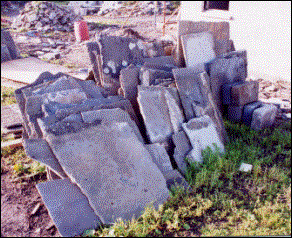
Slates for re-use.
|
|
|
|
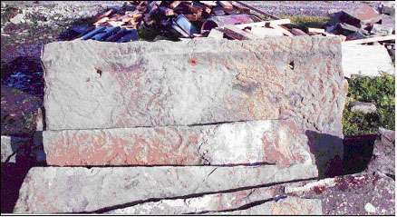
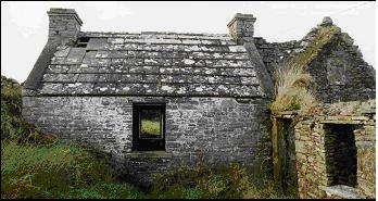
Mohr slate showing the typical
fossilised animal tracks
|
|
| There is little information available
on the use of stone slates prior to the 19th century although there are
examples of thin stone in the walls of very ancient buildings. Donald Stewart
in his tour of Clare in 1788 'for the purposes of searching for and examining
Fossils, Ores and minerals' (Dillon) observed 'In
the Cliffs of the River Shannon, near Kilrush, are remarkably good and
large flags, with impression of almost every kind of animals, herb, etc.
..the flags are in beds, nearly horizontal, form one to six inches thick.'
At Liscannor stone slates were certainly being used at this time. Two examples
are Mohr House in Shingaunagh South townland west of Liscannor village
and Gliggrum House (now Sandfield House) in Ballyellery townland to the
north-east. The latter retained its stone roof until about 1995. |
| By the 19th century the use of stone
slates was well established. A Statistical Survey of the County of Clare
dating from 1808 by Hely Dutton of the Farming Society
described the dwellings of the better off farmers and other more well off
members of the population as having stone slate roofs: 'The better kind
of houses are slated either with a hard thin sandstone flag, procured in
the western part of the county, and near Lough Lickin' and that 'near Innistymon
thin flags are raised, which are used for covering houses; they do not
in general split into laminae thin enough, therefore require strong timbers
in the roof.' |
| First editon (1840) Ordnance Survey
maps show a number of quarries in the Liscannor area and to the SE of Doolin,
demonstrating that quarrying was already taking place before then. There
is no mention of quarrying in the Lahinch area, although there are a number
of quarries indicated further south near Milltown Malbay. |
| A study of valuation records around
the end of the 19th and early 20th century and second edition (1913) OS
maps show a boom in quarrying during the years 1890 to 1915. This was mainly
concentrated to the west and north of Liscannor in the townlands of Moher,
Caherbarnagh, Luogh South and Doonagore. This commercial quarrying was
carried out predominantly by a number of English Companies which came from
the Rossendale region
of Lancashire. This boom in quarrying lasted only about twenty years (1890-1910),
but with the onset of the First World War and the closing of markets the
companies eventually closed and left. These companies included the Liscannor
Quarry Company, United Stone Firms, Wm. Hampson & Co. Ltd. And Geo.
A. Watson & Co. Ltd. |
| G.O. Watson was one of the largest
companies operating at Doonagore with a quarry covering thirty acres at
three sites. Responding to the ready market for the stone they constructed
a three-mile 4ft 8-½ inch gauge steam tramway in 1903/05 which ran
until the company's demise in 1910/11. (Johnson
1997, 19 & 136). |
| The Geological Survey of Ireland
Industrial Mineral Records demonstrates that the quarrying industry did
not completely die out with the departure of the English Companies. The
tradition of local quarrying continued on though now concentrated in the
area to the NW of Liscannor, along the Cliffs of Moher and SE of Doolin. |
| In 1966, another Englishman with
experience of quarrying in Rossendale, Harold Phillipson opened a quarry.
He had previously worked with a blacksmith who had been employed in Watsons
Quarry at Doonagore prior to the 1st World War. At that time there were
only a few local men working the quarries at Moher and Luogh. As there
was not much of a market for the sandstone at the time quarrying was not
a full time occupation, it was generally a sideline to the main occupation
of farming. |
| Harold Phillipsons first quarry
works was situated near where the present Liscannor Stone Company headquarters
is in Luogh townland. This was at the time of rural electrification and
Phillipson paid £15,000 to be connected to the ESB. He employed locals
but work initially was very slow as there was very little building going
on but an order of stone for the Kennedy Memorial Park saved the company
from going under. Subsequently the market improved with orders for the
Rent an Irish Cottage Schemes and from the Office of Public Works. The
main demand was for flags for flooring, buildings stone and walls, but
not stone slates. In 1968, Roger Johnson joined him. The company developed
further with the help of small industries grants. Johnson later bought
the company in partnership with P.J. Ryan from Phillipson to form the present
Liscannor Stone Company. Today stone slates are quarried locally usually
from Luogh or Moher Slate. The slates are available in sizes from 1150mm
x 880mm to 450mm x 450mm with thickness varying between 13mm to 25mm -
½ to 1. |
|
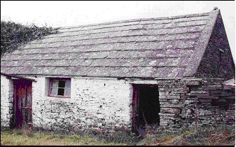
|
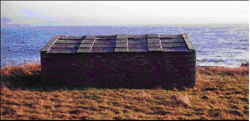
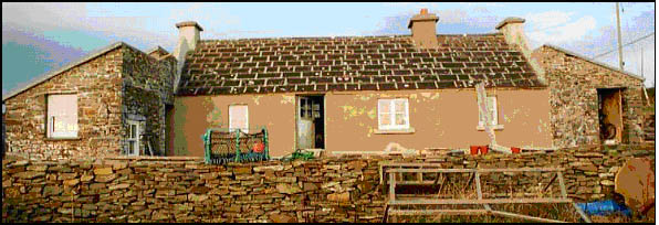
A Clare stone roof today
|
|
| Most buildings have simple gable
ended roofs with very little or no examples of hipped roofs, dormer windows,
or valleys. This paucity of roof types reflects the limitations imposed
by the large and somewhat cumbersome stone slates but also reflects the
simple vernacular architectural style. Given the immense roof weight many
roofs display solid timber trusses and purlins. Pitches of more than 40º
are generally not found. Rafter centers were generally in the region of
between 310mm to 380mm. In nearly all cases battens were attached directly
onto the rafters. There was only one example of roofing felt found. Stout
to more slender purlins were also sometimes used measuring between 185mm
and 150mm in section. Through purlins were generally used with one example
of butt purlins used. The wall thicknesses varied between 540mm to 755mm.
In all cases a ridge plank was used to form the apex. |
| The stone slates are randomly sized
laid to diminishing courses with the heavier and larger slates placed near
the eaves and the smaller ones near the ridge. Each successive course of
slates was chosen to provide adequate head and side lap over the previous
course of slates. According to local sources the traditional system was
to lay the battens to the size of the flag or slates coming out of the
quarry at that time. However, there was little information avaialable on
specific methods of slate laying employed, but it is likely that it was
similar to methods employed in England. |
| The average
head lap varied between 127mm and 203mm (between 5 and 8 on roof case
studies). This lap was larger than in the case of natural slate due to
the characteristic undulations of the sandstone especially found in the
Moher slate with its characteristic fossilised trails. Luogh slate due
to its smoother nature could be laid to a lesser lap. It was imperative
that a range of widths was available to the slater to allow sufficient
side laps otherwise slates would have to be cut to fit which in todays
terms would be a waste of expensive slates and labour. |
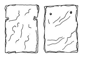
| The slates
were attached by iron nails through a double set of holes near the head
of the slate or via side notches (Fig. 8). The heavier and thicker slates
(known locally as flags) used on outbuildings were often just hung from
nails, which rested in notches picked out from the underside of the stone.
The stone slates used on outbuildings are known as flags due their immense
weight and size and could be up to 55mm (2) thick. The immense size and
weight of the stone meant that as a rule they stayed insitu. Battens
were often not used so nails were hammered directly into rafters or purlins.
A house in Doolin, prior to its present Luogh slate roof, had an earlier
roof where the stone slates were attached to battens with bog deal pegs.
The pegs tapered to a point which were inserted into the battens to attach
the stone slates. |
|
|
On earlier roofs slates were
fixed with wooden pegs and later with two iron nails at the top corners
or at the sides (above) or hung from nails which rested in notches on the
slate's underside (below)
|
|
|
| According
to a local builder, recalling stone slate roofing that he saw carried out
in the 1950s, the battens were laid as the work progressed because of
the randomly sized slates. If this is the case, it shows that already at
an early stage in the decline of stone slate roofing some of the traditional
skills were being lost. |
|
| The decline of these roof coverings
does not just result in the decline of individual roofs but also in the
loss of character of a street, a group of structures, an area and ultimately
a landscape. The material provides a sense of place and adds to the relationship
between the land and its people, thus making it a valuable feature of the
landscape. Elements of the landscapes past history of use such as ringforts,
holy wells and old field systems are already protected, so is it too much
to ask that this characteristic element be protected and retained as well? |
|
Finch, T. F.,
Culleton, E. & Diamond, S. 1971 The Soils of County Clare. Dublin.
An Foras Talúntais (The Agricultural Institute).
Dillon K.,
1953 Donal Stewart and the Mineral Survey of Ireland in North Munster Antiquarian
Journal Vol. VI. No. 5.
Dutton, H.
1808 Statistical Survey of the County of Clare; with observations drawn
up for the consideration of the Dublin Society. Dublin. Graisberry &
Campbell.
Johnson, S.
1997 Johnsons Atlas & Gazetteer of the Railways of Ireland.
England. Midlands Publications Ltd.
Wilkinson,
G. 1845 Practical Geology and Ancient Architecture of Ireland. London. |